Command
Plan, confirm and execute with aircraft state always visible.
Tactical mission management platform
TAC-GCS unifies aircraft control, mission planning, dispatch, automated return-to-hangar, airspace awareness and TAK interoperability in a ground control station built for disciplined public safety and enterprise UAS operations.
*Subject to licensed seat count.
Designed, owned and developed by AirCAV Global LLC
THE OPERATIONAL PROBLEM
TAC-GCS puts the operator’s aircraft, mission geometry, telemetry, airspace context and team network into a single view—so the command loop stays clear from dispatch through recovery.
Plan, confirm and execute with aircraft state always visible.
Control multiple aircraft without losing per-unit mission context.
See traffic, ceilings, fences, routes and operating data together.
Publish aircraft and exchange operational information through TAK.
THE PLATFORM
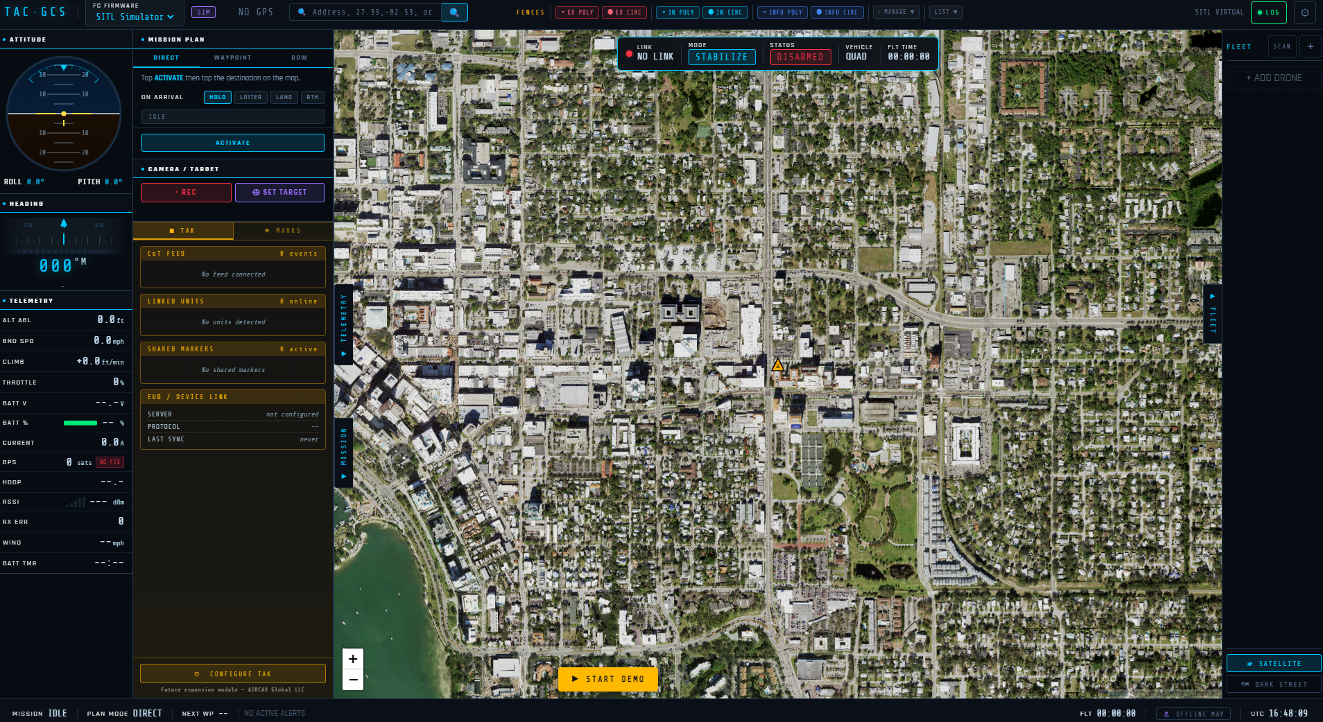
Each view is an actual TAC-GCS interface screenshot. Select the primary image to inspect it at full size.
01 / 17
Mission planning, flight telemetry, TAK context, mapping and fleet state in one operational workspace.
FROM CALL TO AIRBORNE
For DFR and rapid-response programs, TAC-GCS turns a searched or clicked location into a unit-aware aircraft dispatch, then brings the aircraft home to its hangar with one control, while preserving pre-arm checks and explicit operator confirmation.
Search an address, coordinate or what3words location—or select directly on the map.
Choose the responding aircraft with distance, availability and link state visible.
Review readiness, target AGL and the exact command sequence.
Track route, telemetry, airspace and team context while every aircraft is monitored for failsafes and unexpected events.
Return the aircraft to its assigned hangar with one control, including marker-guided precision landing on ArduCopter.
DFR HANGAR & AUTOMATED RETURN
Each aircraft is assigned its own hangar. One control brings it back and lands it on the pad, even if it set down somewhere else first. Because the hangar becomes that aircraft’s home point, its own onboard return and failsafes lead back to the hangar too.
CAPABILITY BY DESIGN
TAC-GCS is more than a flight screen. Each operational layer remains usable as the mission grows—from one aircraft and operator to a connected fleet and common operating picture.
Direct dispatch with automatic rerouting around active geofences, waypoint missions, survey grids, orbit/loiter, perimeter patrol loops and abort-to-hold behavior.
Up to 10 simultaneous aircraft subject to license, mixing ArduCopter and PX4 and radio and network links, with independent telemetry, transport, mission, home, track and color state.
Selectable maps, offline tile caching, address search, coordinates, distance, track history and camera field of view.
FAA UAS Facility Map ceiling overlays and live ADS-B traffic with automatic failover to two backup sources, alongside mission geometry.
Inclusion, exclusion and informational geometry, GCS enforcement, persistence and onboard AGL ceiling management.
Mutual TLS, QR and certificate enrollment, aircraft and command-post publishing, GeoChat, shared incident markers, linked units and emergency alerts.
Stream large agency datasets (a 1.2 GB, 312,000-feature county parcel file loads in under four seconds), define an AOR, inspect attributes on demand and manage reusable layer profiles.
Continuous pre-arm state, GPS/EKF health, battery condition, guided calibration and parameter management.
Per-aircraft hangars, one-button return and landing, hangar-as-home failsafe behavior and ArduCopter precision landing.
Every connected aircraft is watched for unexpected disarms, failsafe changes, critical onboard messages and self-initiated RTL or LAND, whichever one is in focus.
TAK INTEROPERABILITY
TAC-GCS operates as a TAK End User Device. Aircraft publish as distinct CoT tracks, the command post can publish at home, and linked units, alerts, GeoChat and shared markers remain available to the operator.
AIRCRAFT COMPATIBILITY
Mission, parameter, geofence, calibration and precision-landing workflows are engineered around ArduCopter.
Arming, take-off, flight modes, missions including loop patrol and survey, dispatch, orbit, RTL and return-to-hangar. Firmware is detected automatically per aircraft, so ArduCopter and PX4 fly in one fleet. Parameter, calibration and precision-landing tools remain ArduCopter features.
Mode decoding is supported. Copter-shaped mission, parameter, fence and calibration workflows require care.
A self-contained interface training aid. It does not transmit MAVLink or replace flight validation.
DETAILED FEATURE REFERENCE
Expand each category for a concise technical view of the current platform.
Serial/USB, UDP and MAVLink-over-WebSocket; several SiK radios at once, one per aircraft; per-aircraft transport memory; IPv4/IPv6 fallback; heartbeat and link-loss monitoring, with a lost link affecting only that aircraft.
Outbound MAVLink 2 command and mission traffic with selective MAVLink 1 compatibility; inbound MAVLink 1 and 2 parsing with CRC validation.
Search by address, decimal coordinates or what3words with a choice of Nominatim, Google, HERE or Amazon Location geocoding; dispatch an aircraft with HOLD, LOITER, LAND or RTL on arrival; automatic rerouting around active geofences.
Create, edit, reorder and upload waypoint missions; lawnmower survey generation; orbit and counted or infinite patrol loops.
Named pre-arm failures, explicit command confirmation, system-level emergency hotkeys with conflict warnings and safe remapping, held-key repeat protection and tracked parameter changes.
Artificial horizon, AGL/MSL altitude, speed, heading, climb, battery, GPS, link quality, timer, MAVLink log and post-flight BIN analysis.
Plain TCP or mutual TLS, data-package import, certificate and QR enrollment, profiles, auto-reconnect, linked-unit symbology, local unit aliases, NAPSG-style incident markers and event logging.
Offline map tile cache, built-in voice alerts without a cloud service, offline license enforcement after a one-time activation and a self-contained interface training profile.
FAA UAS Facility Map ceiling overlays; live ADS-B traffic from a primary source with two automatic backup sources and a live / backup / off status indicator.
Per-aircraft hangar assignment bound to the flight controller hardware; one-button return and landing, including from a remote landing site; hangar set as the aircraft’s home point; surveyed pad elevation; rally-point warning; failsafe override; ArduCopter precision landing with marker-loss handling.
Continuous per-aircraft detection of unexpected disarms, failsafe flag changes, critical onboard messages and autonomous RTL, LAND, SMART_RTL or BRAKE entry, independent of which aircraft is in focus.
OPERATOR-FIRST SAFETY
TAC-GCS surfaces aircraft readiness, names failing pre-arm conditions and uses deliberate confirmation for high-consequence commands. Emergency keyboard controls are registered at the operating-system level and remain available when a mouse or interface path cannot be relied upon, and every connected aircraft is monitored for failsafes and unexpected events.
DFR return-to-hangar, precision landing, PX4 support and multi-radio operation are verified in ArduPilot and PX4 simulation; field validation on production aircraft is in progress. Operations remain subject to agency policy, aircraft configuration and applicable aviation regulations.
TAC-GCS by AirCAV Global
Discuss deployment, integration, fleet licensing, training or an OEM opportunity with AirCAV Global.
Request a TAC-GCS briefing →